
Quick ATC/IFR tricks: Did you know that? - Part 2
- TIPAH

- 2 janv. 2019
- 3 min de lecture
This series of quick tricks regarding ATC and/or IFR rules, will shed some light on small details that one generally does not pay attention to and therefore one ignores most of the time.
In this part 2, we will focus on all the acronyms related to the altitude that can be found on either VFR or IFR navigation enroute charts or IFR approach plates.
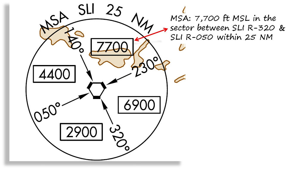
MSA
The MSA acronym stands for Minimum Sector Altitude which is the lowest altitude that will provide a minimum clearance of 1,000 ft above all objects located in a given area within a 25 NM radius centered on a radio navigation aid.
MEA
This is the Minimum En-route Altitude. It corresponds to the altitude for a segment of route and it provides enough reception of radio navigation and ATC communications within the airspace while assuring the required obstacle clearance.
The MEA for “T” routes (Low altitude area navigation RNAV routes) appears with a "G" next to the altitude.

MOCA
This acronym stands for Minimum Obstacle Clearance Altitude and is the minimum altitude for a defined segment and the MOCA provides the required obstacle clearance. It is important to note that the plane, even if respecting the MOCA, can be below the ATC coverage (MRVA) and/or below the minimum reception altitude (MRA).
It is important to note that in the US, the MOCA assures 22 NM VOR reception range and it is depicted with a * above the airway.
The Minimum vertical separations are:
1,000 ft when obstacle elevation is below 3,000 ft
1,500 ft separation when obstacle elevation is between 3,000 ft to 5,000 ft
2,000 ft separation when obstacle elevation is greater than 5,000 ft

MORA
This is the Minimum Off Route Altitude. By respecting the MORA, one ensures a minimum of 2,000 ft of terrain clearance when flying in mountainous areas and 1,000 ft when flying in non-mountainous regions. This safety clearance extends up to 10 NM from the route centerline.
The GRID MORA provides clearance for both terrain and human-made structures within the section outlined by latitude and longitude lines.
The GRID MORA value ensures 1,000 ft of clearance from terrain and human-made structures in areas where the highest elevations are 5,000 ft MSL or lower and by 2,000 ft in areas where the highest elevations are greater than 5,001 ft.

MCA
The Minimum Crossing Altitude is the lowest altitude at which a NAV fix can be crossed in order to enter or join an airway. This ensures the plane to fly at an altitude while being clear of all obstacles during a climb to the required minimum en route IFR altitude (MEA) needed to fly the airway beyond the fix. The MCA does not only take into account the clearance in regards of the obstacles but it ensures a good quality of the NAVAIDS signal reception too. The MCA is depicted by a flag [X].

OROCA
The Off Route Obstruction Clearance Altitude is represented in thousands and hundreds of feet AMSL. This is the highest possible elevation that includes all obstructions/terrain in between the latitude and longitude lines.

MRA
The Minimum Reception Altitude (MRA) is the lowest altitude on an airway segment so that the plane is ensured to receive signals from NAVAIDS like VOR or NDB and it is depicted with a [R].

Minimum Vectoring Altitude (MVA or MRVA or ASMA)
The Minimum Vectoring Altitude is the lowest altitude (in ft AMSL) to which a radar controller may issue aircraft altitude clearances during vectoring/direct routing except of otherwise authorized for radar approaches, departures and missed approaches.
The MVA can also be called the Minimum Flight Altitude MFA, Minimum Radar Vectoring Altitude MRVA or ATC Surveillance Minimum Altitude ASMA depending on the source.
The minimum vectoring altitude in each sector provides 1,000 ft above the highest obstruction in non mountainous areas and 2,000 ft above the highest obstacle in designated mountainous areas.

MHA
The MHA stands for Minimum Holding Altitude and this is the lowest altitude below which one cannot fly while in a holding-pattern. This minimum altitude ensures both enough communications and NAVAIDS signal reception but also ensures the required obstacle clearance.

MAA
This is the Maximum Authorized Altitude (MAA). This altitude represents the maximum usable altitude or flight level for an airspace or a route segment.
E.g. T208 RNAV route has a MAA of 15,000 ft MSL as shown below.

TIPAH


Commentaires